CRADLE MT. (5069'), BARN BLUFF (5114'), MT. BROWN (4607') (now MT. EMMETT)
by
Keith Lancaster
Note: The reports have been scanned in as written. I have included the height and distance indications, e.g.:
(1000'- 12m.- 4.45p.m.)
which read as follows: height in feet - miles for the day - time.
| We were away at 2 p.m., as soon as possible after dinner. The car passed through Carrick (11¼m., 490') at 2.20 p.m., Westbury (20m., 590') at 2.32 p.m., Elizabeth Town (38m., 720'), Sheffield (57m., 950') at 3.35 p.m. and Wilmot (69½m., 940') at 4.10 p.m.. Seven and a half miles further on, we passed the track to Bell Hill and reached the junction of the Middlesex Plains and Liena thoroughfares (85m., 2600') at 5 p.m. |
A few miles farther on, the very rough portion of the road commences and the last twelve miles has to be traversed at snail pace through muddy bogs and small creeks, over slippery grass, corduroy and rock-strewn track, at times deviating amongst the trees, to avoid several impassable stretches of the route, at many times hard-pressed to keep the car in motion through the slippery mud and to keep the steering under some sort of control as the slithering rear wheels threatened to turn the car completely around. Fortunately, the State Government has men now working on the road and hope to have it in good shape in a year's time. The last two or three miles of the route is roughly metalled and better progress could be made but one had ever to be on the qui vive for the intermittent obstacles that would suddenly appear.
It was dusk, 7.35 p.m., when we reached 'Waldheim' (100½m., 3120'), the mountain chalet at the end of the road. Although there were twenty other visitors at the chalet, we were able to secure accommodation in one of the little shacks dotted around the chalet.
We were astir at daybreak and, after a light breakfast, set off along the Waldheim-Lake St. Clair track. We chose the western or 'Bridle' track, a well-graded route leading southwards. Just over three miles from 'Waldheim', we reached the turn-off to Cradle Mt. (4175') at 6.40 a.m. Soon we were climbing up the rocky side of Cradle and it was not long ere we gained the summit. Then followed a clamber along the uneven and snow-dotted top of the mountain towards the south where we happened upon the cairn that marks the highest point (5069') at 7.25 a.m., four and a half miles out.
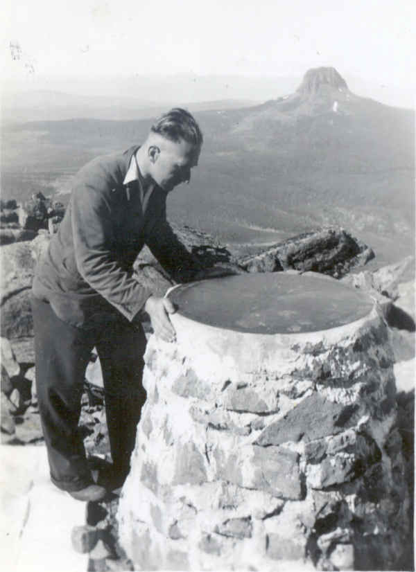
Alongside the cairn is the brass dial, pointing out every point of interest that can be seen in the wide and marvellous panorama. Except for a few isolated clouds, chiefly in the north-west, the sky was clear and we were able to view practically the entire field available from the blurred outline of little Mt. Arthur to the snow-capped heights of the mighty Frenchman. We were most impressed by the unusual grace of our lofty neighbour, Barn Bluff, with its steep broken walls - the stupendous mass of Pelion West and the colossal bulk of Ossa, rearing its snow-decked head apparently higher than all its neighbours - the height and beauty of Pelion East and the Du Canes - the towering pinnacle of Eldon Peak - the all-appealing Frenchman - the deep gorges of the Fury and the Forth and the magnificence of the countless lakes and tarns.
| In order to describe the view from Cradle Mt., considerable assistance is procurable from the directing dial on the mountaintop. Following on those lines the entire view is, briefly as follows: due south lies Frenchman's Cap (4756'), 70 miles away; S. by W. Eldon Bluff (20m.); S.S.W. is Barn Bluff (5114', 2½m.); behind which Eldon Peak (4789') appears, then coming Mt. Owen (31 miles distant); S.W. by W. and 28 miles away, Mt. Sedgwick can be seen with little Mt. Inglis (6 miles) to the westward; S.W. and ½ miles below us, lies a portion of the Fury Gorge with Mt. Dundas (3933') bringing up the skyline, 27 miles beyond; S,W. by W. Sophia Peak rises 13 miles away and next to appear is Mt. Murchison, 21 miles distant; W.S.W. is Mt. Agnew with Dante's Inferno occupying the foreground a couple of miles away; just S. of W. Mt. Romulus appears 13 miles distant; 36 miles due west is the Meredith Range; W. by N. the Norfolk Range is visible 56 miles away; W.S.W. Sutton's Gorge can be seen half a mile away with Mt. Remus another eight miles beyond; N.W. by W. the tiny scarred cone of Mt. Bischoff (2596'), 28 miles, is distinguishable with Mt. Pearse (20m.) to the north; N.W. Mayday Mt. Appears, 10 miles away; N.W. by N., St. Valentine's Peak (3637') arrests the eye with Hounslow Heath (3m.) occupying the foreground; N. by W. is Black Bluff (4381', 16m.); due N. appears the Dial Range (30m.) alongside Stormount, 13 miles; N.N.E. Mt. Campbell lies but two miles distant with little Bell Mt. (15m.) visible above its summit; N.E. lies Mt. Roland (4047', 23m.) with Magog (30m.) farther eastward; E.N.E. lies little Mt. Arthur (3895' ), 74 miles away, then coming Western Bluff (otherwise Extreme Tier) just 20 miles distant; just N. of E. appears the Devil's Gullet (20m.); E. is Ironstone Mt. (4736', 27m.); E. by S. lies Clumner's Bluff with the Walls of Jerusalem in the E.S.E.; S.E. by E., Mt. Pillinger (13m.) is located just north of Mt. Brown (4607', 2m.); a little S. of S.E., Cathedral Mt. (15m.) is prominent, followed by little Mt. Oakleigh (9m.); S.E. by S., Mt. Pelion East (13m.) towers high over Oakleigh; just south of Pelion East and in line, Lake McRae (5m.), Mt. Doris (14m.) and the Du Cane Range (17m.) appear, closely followed by high and mighty Mt. Ossa (12m.); S.S.E. Mt. Gould can be seen, then coming Mt. Thetis (10m.) and next the gigantic form of Pelion West (9m.); S. by W. lies Mt. Achilles followed by Castle Mt. (22m.) and once again the towering Frenchman reasserts himself in the south. |
An hour is much too short a period in which to adequately view the entire surroundings but we were anxious to press on to Barn Bluff and enjoy the panorama from that angle before any possible cloud formation could interfere with our desires. Accordingly we sat out at 8.30 a.m. and descended the mountain on the southern side by way of a steep and rocky defile. Half an hour later, we regained the Waldheim-Lake St. Clair track - the aneroid registering 4075' and the pedometer, 5½ miles out from Waldheim.
Continuing along the track a further 1¼ miles, we gained the turnoff to Barn Bluff (alt. 4000') at 9.25 a.m. and left five minutes later en route for that eminence. We began the ascent via a hill to the north of the peak to which it is connected by a high ridge. Soon we gained the rocks and found the rock-climb steep but comparatively short. The highest point is at the western end of the mountain top and at 10.40 a.m. we were in occupation of this 5114' goal - ped., 9 miles out from Waldheim.
Scarcely a cloud remained in the sky and below us was unfolded a most remarkable and extensive panorama, indeed. Never before had we seen below us so many mountains as from this lofty vantage point. Generally the view is similar to that just described from Cradle Mt. which presents a rugged picture over to the N.N.E..
Mt. Olympus is discernible between Mts. Thetis and Achilles while Mts. Rufus and Hugel appear on the west of Pelion West. Lake Will lies at the southern foot of the peak and Lakes McRae, Windermere and a host of tarns dot the plateau farther southwards. A much closer view may be had of the Fury Gorge to the west. Apart from these new features, all points visible from Cradle Mt. Are also available from Barn Bluff and therefore are not listed to avoid unnecessary repetition.
At 11.50 a.m. we bade farewell to Barn Bluff's unrivalled panorama. We had planned to climb Mt. Brown on the return journey if such was practicable. Feeling the strain of the climbing, I dropped behind my companion and thus we were deprived of consultation. Seeing him selecting practically a direct course to Mt. Brown and believing such to be a more difficult route to the peak than the one I had in mind, I decided to continue on in the direction of Cradle Mt., passing the Windermere turnoff (4000' - 11¼m.) at 12.55 p.m. after a delay caused by awkward scrub. Reaching the shoulder which joins Mt. Brown to the Cradle Mt. - Barn Bluff Col, I turned to the right towards Mt. Brown.
From the distance, Mt. Brown appears like a huge pile of pebbles, but on close approach it proves to be composed of unusually broken rock, almost entirely devoid of any vegetation at all. Although reaching the respectable altitude of 4607', it is dwarfed almost to a hill alongside its monstrous neighbours. Extremely weary and suffering acutely from cramp in both legs, I slowly struggled towards the third peak of the day. At 2.15 p.m. with the pedometer at 13¾ miles, I at last made the summit of the third member of that massive mountain triangle, to find that I had just been forestalled by my companion who had experienced a more difficult journey across the defile.
A grand view of Cradle Mt. from a new angle at close range makes an impressive appeal, a glorious vision of that most majestic of our mountains, Barn Bluff, deservedly earns one's admiration, a further glimpse of the Pelions, Mt. Ossa, Oakleigh, etc. is appreciated but perhaps the highlight of the whole panorama lies in the area to the S.W. where the Brown River is born. Probably Tasmania's best illustration of glacial action in the Ice Age lies indelibly recorded here. The Barn Bluff-Cradle Mt. Connecting ridge is carved off on the S.E. side by a gigantic glacial cirque. Below the cirque, a display of glacial erratics occurs, the rocky gully having been torn about in most unsymmetrical fashion. Further afield, glacial moraines reveal more evidence of the tremendous glacial pressure existing ages ago. Many tiny waterfalls leap in dazzling splendour over the irregular cliffs below, several shimmering lakes and countless tarns glisten in the sunlight at various altitudes, and all contribute to the insatiable appetite of the Brown River which carves its way eastward to augment the Mersey.
At 3 p.m. we bade farewell to Mt. Brown and commenced the laborious homeward trek. After regaining the Waldheim-Windermere track, I recovered somewhat from my disabilities and made good progress. The Cradle Mt. turnoff (4180' - 18½ miles) was effected at 4.15 p.m. and we had a chat with a party of fellow tourists who had visited Cradle. At 4.35 p.m. we were once more in action and the remainder of our journey to Waldheim passed without incident. Waldheim (3120') greeted us at 5.30 p.m. after a record day's walk of 21½ miles, including considerable arduous climbing. We enjoyed a pleasant evening at the chalet, looking over many fine photographs of beauty spots within the reserve and hearing the experiences of Mr. J. Connell, the chalet host, as only he could relate them.
Needless to say, we were abed fairly early and made the return trip to Launceston next day - not without further misadventures on the wretched road.
If
you would like more information on Keith Lancaster's diaries, please feel
free to send me an email.