| |
A
TRAVERSE OF THE ELDONS by Keith Lancaster |
| Home to Index | |
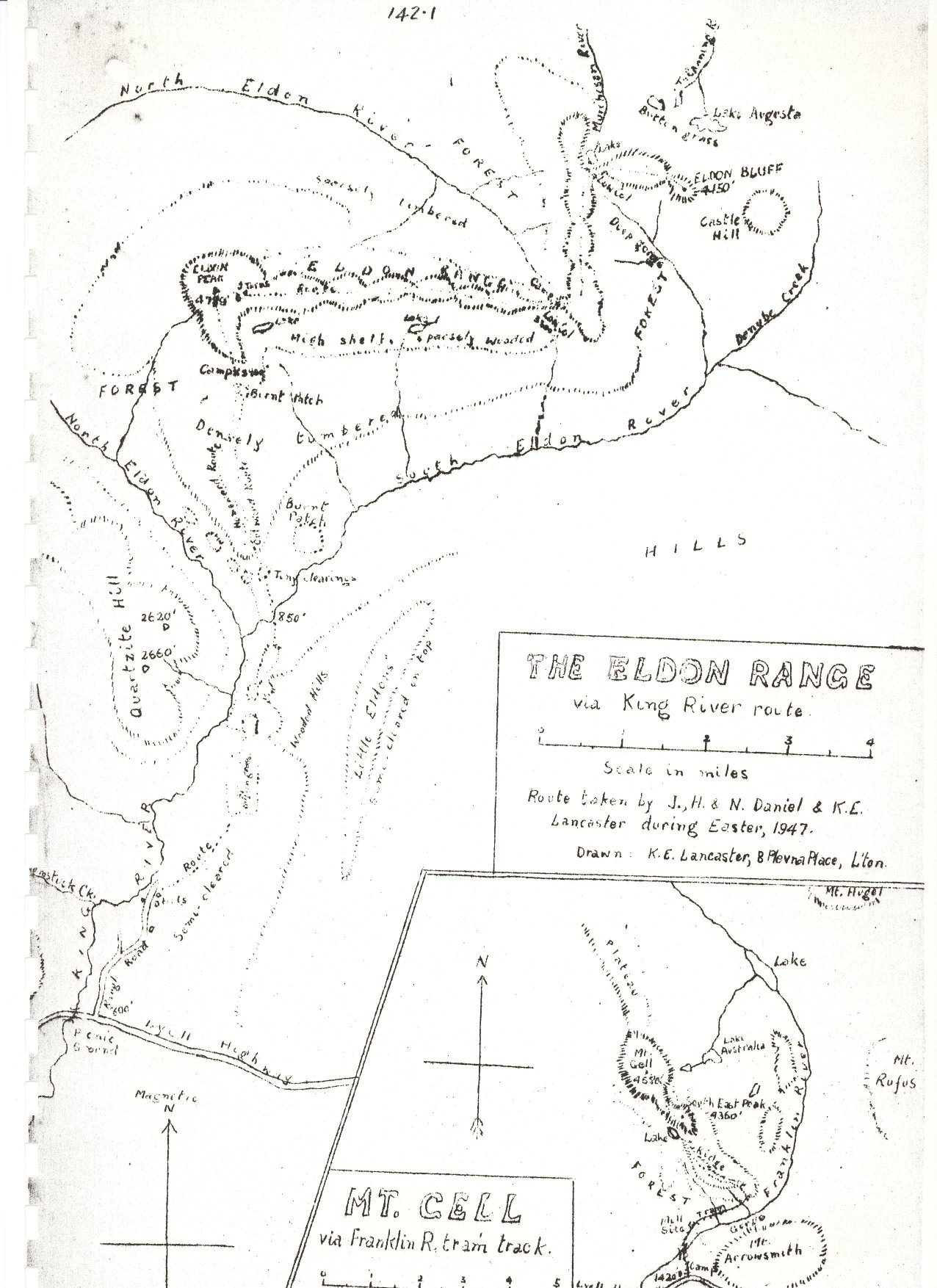
Note: The reports have been scanned in as written. I have included the height and distance indications, e.g.: (1000'- 12m.- 4.45p.m.) which read as follows: height in feet - miles for the day - time. Map of the Eldon Range. This image is scanned in from a diary page and is not of the best quality. |
Taking advantage of the four day Easter break, Jack, Harold, and Norm. Daniel and myself left Launceston at 7 p.m. on Thursday, April 3rd. 1947 with the object of climbing both Eldon Peak and Eldon Bluff. We made excellent progress in the car over the usual route until mist was encountered around Mt. Projection and, although at no time intense, it persisted at frequent intervals throughout the evening's journey. Reaching the Burns' Creek hut under Mt. King William 1st. (2580’ – 113m. - 10.45 p.m.), we made camp for the night, being awakened after midnight by the arrival of a section of the Hobart Walking Club. Astir early on Good Friday morning, we were on our way at 6.40 a.m. along the Lyell Highway, threading our way along the windy and attractive road to reach the King River picnic ground (800’ - 36m. - 8.12 a.m.). From here we turned right along the rough woodcarters' road which follows the river up for a short distance, bringing us to a group of huts at its present terminus (820’ – 37½m. - 8.30 a.m.). An early morning mist had completely lifted from the river valley as we set off on foot at 9.15 a.m., a few clouds dotting the sky but the weather appearing quite favourable. Utilising the easy going afforded by a mixture of tussocks and scattered button grass, we were soon opposite the southern end of Quartzite Hill and, coming to the end of the big button grass patch, we were soon through the short ti tree band which hid the next section of button grass and, soon accounting for this small patch, re entered the next band of ti tree in quest of the long button grass stretch visible from Quartzite hill. This ti-tree band was much wider with the ti tree much thicker and mixed with cutting grass and macquarie vine. When we did break out into the open, we found that the amount of button grass was far below expectations and, ever and anon, we had to burst through low ti tree patches with their allies in resistance the macquarie vine and cutting grass. This was our first encounter with the macquarie vine in its prolific state and it provided a most formidable undergrowth. Climbing and twining around the ti tree and cutting grass, it permitted no opportunity of breaking through or squeezing under its woven mass and there was nought to do but force a way over the top. As the vine apparently requires a fair amount of sunshine for its existence, it fortunately is not found in the tall ti tree but is at its worst on the edges of the clearings. The failure of the long open stretch of button grass to materialise and the slow progress made through the low ti tree, made our plans for climbing Eldon Peak late that afternoon quite remote. After leaving the ti tree behind, we encountered wattle with bracken fern undergrowth, before reaching the South Eldon about half a mile above its confluence with the North Eldon, crossed it and set about dinner (850’ – 5m. – 12.15 p.m.). From this point, Eldon Peak loomed very close in the north, with Quartzite Hill occupying the west. At 12.57 p.m. we set sail through more wattle, bracken fern and dicksonia, meeting an endless confusion of decaying logs beneath the bracken. There is unchallengable evidence in the huge and rotting fallen trees and in the dead trees still standing on the slopes of the Eldons that a great forest once flourished in this valley, but whether abnormal seasonal conditions of the past or the sulphur from Mt. Lyell's earlier mining days had caused its collapse is a matter for investigation. The fact remains that the existing tree-growth is relatively young, permitting undergrowth of all kinds to thrive and the remains of the old forest are rotting fast. At 1.28 p.m. we emerged upon a small button grass patch and immediately entered the ti tree at the southern foot of the long shoulder leading right up to Eldon Peak. Once beyond the ti tree belt, progress improved immeasurably, laurel and occasionally horizontal and cutting grass forming the undergrowth of the mixed myrtles, sassafras and gums. The route along the crest of the ridge was fairly steep and, approaching the 2000’ height, became less friendly, bauera, ti tree and cutting grass often reducing progress to a crawl. Light rain, too, added to our discomfort. Thus it was with much relief that we gained the temporary respite of a small burnt patch on a flat shelf on the mountainside. Low clouds just above us prevented a sight of the peak above as we crossed the burnt patch and entered an area clothed in a mixture of button grass, cutting grass, bauera and low gums. We chose a relatively dry spot on this wet ledge for a camping site, and thus ended the first day's toil (2900’ - 9m. – 5 p.m.) with Eldon Peak still some little distance away beyond the gum slope immediately ahead. Fortunately the light intermittent rain soon ceased and the morning dawned fine with a thick mist enveloping the King R. and South Eldon R. valleys. The sun was lighting up Eldon Peak which looked surprisingly close overhead as we commenced Saturday’s march. The short tussle with the gums, ti tree, hakea, etc. on the slope ahead left us very wet and cold but the arrival of sunshine as we breasted the low alpine growth beyond produced a welcome counter. Soon we were on the rock-climb which proved easy and led right to the cairn on Eldon Peak (4789’ – 2m. 9.20 a.m.). The clouds were lifting from all the valleys and, propelled by the northerly
wind, the cloud mist from the North Eldon valley was being blown over
the range, reducing visibility to occasional glimpses to the west and
south. The view must be wonderful from here on a clear day as many wild
and rugged peaks and hills rise within close proximity. We were able to
secure a glimpse of the following during our short sojourn on At 10.8 a.m. we left Eldon Peak, descending through the mist on the east to a few plateau tarns and continuing eastward along the crest of the range. The range is very narrow and just as irregular, consisting of a succession of rocky heights generally over 4000’ in height separated by narrow cols and skirted by either steep slopes or cliffs. In spite of the general irregularity and ruggedness of the ridge, our experiences testified to the advantage of observing a complete traverse or near traverse of' the range. The increasing sunshine had dried the exposed rocks and rubber boots showed to conspicuous advantage over leather on the bare rock. The east west ridge receded in height towards the east and at long last we dropped down on the low col which joins up with the north south continuation of the range. Here we hoped to find water (none had been seen since leaving the tarns) and a camp site and we were not disappointed, parking ourselves on the farther side of the col for dinner (3300’ – 7m. – 1.40 p.m.). We had not lived un to our schedule and it was apparent that Eldon Bluff (still obviously a long way off) would have to be scaled that afternoon and this campsite regained or time would defeat us in our four day objective. It was at this stage that Jack made a big sacrifice in volunteering to remain behind with the packs and prepare camp whilst the remainder pushed on to Eldon Bluff. Unfortunately, Jack had been unable to strike form on the trip and the rock-going had accentuated his difficulties and he considered his condition not up to the afternoon task. His decision to stay behind contributed in no small degree to our success and the advantage of his team work was even more obvious on our benighted return. At 2.18 p.m., Harold, Norm and I set off up the eastern climb from the col, the freedom from our packs lending us new energy. More than half an hour expired ere we gained the top of this north south ridge and, turning northwards, we pressed along the crest over similar rocky undulations as experienced on our morning climb. The scenery was grand around here, ravines, cliffs, forests, lakes and waterfalls appearing on both sides with the mountain giants showing out to marked advantage in the north and east where clouds no longer barred the scene. After about a mile and a half along this northerly route, a change in direction was necessary once more eastward. Forsaking the north south ridge, we descended to a low col with a pretty little lake on one side (the headwaters of the Murchison) and a steep forested ravine on the other. A steep ascent then followed, bringing us out on top of a high tableland and presenting us with a half mile's easy level walking, the first for the day. From the eastern edge of this, the jagged serrations of Eldon Bluff were but yards away and the great rock columns, rock chimneys and cliffs lay revealed in gorgeous and fantastic splendour. Another descent to a rocky razor back col, followed by the inevitable ascent over jagged boulders and we annexed the summit of Eldon Bluff (4450’ - 11m. - 4.45 p.m.). Fifteen invaluable minutes sped by as we took but the briefest view from
this rocky and exposed perch, occupying the eastern extremity of the Eldons.
The scene to the eastward is almost unparalleled and a day could be spent
revelling in the extensive and varied panorama. Pelion West, Barn Bluff
and Olympus were superb, the following being an abridged summary of the
peaks to be seen: At 5 p.m., with shadows lengthening, we commenced the journey back to
camp. Steady progress was maintained throughout and we gained the north
south ridge as the sun set. With a slight drop in the nor' westerly, the
clouds were losing height with the evident intent of reposing in the many
valleys for the night. The twilight was short lived and the rising of
the full moon contributed little to the diminishing light. With our sleeping quarters established and tea as good as ready, we were able to retire about 9 p.m. and, although our little tent was exposed to the cold wind, we spent a comfortable night. Next morning (Easter Sunday) dawned bright and fine with mists resting in the valleys on both sides. At 8 a.m. we were under way along the east-west ridge towards Eldon Peak. As we slowly traversed the ridge, the rising sun made our task warm. In avoiding a traverse of one of the eminences on the ridge by deviating to the right, we discovered a natural ‘race’ which provided an excellent path during its short career and, near the termination of this ‘race’ on a cliff, we discovered some very deep crevices in the rock, probably 100’ deep. The hard rock traverse was as good as over when we halted at a small tarn at the foot of Eldon Peak (4230’ – 4½m. – 11 a.m.). One could have lain down on the soft growth near the tarn in that warm sunshine for hours, but our old enemy, time, could not be disregarded. Resuming at 11.43 a.m. with cloud and mist practically absent and a glorious view wide open before us to the south, we passed over the shoulder of Eldon Peak and gained the rock slide below and so on down to our Friday night camp site (2900’ – 6½m. - 12.55 p.m.). Here we had dinner and at 2 p.m. pushed on down the mountain side, encountering more difficulty from the scrub and in maintaining direction than during our ascent. At 4.22 p.m. we reached a small button grass patch at the foot and then waded through the fern, ti-tree and wattle beyond to reach the South Eldon, much nearer its confluence with the North Eldon than on the outward course (840’ - 11m. - 5.8 p.m.). After lengthy argument on the merits of fording the stream or searching for a log crossing, we compromised by constructing a log bridge and effected a hazardous though successful crossing. We made camp a few yards further down stream amid beautiful surroundings with fine river sand as our camp floor. Next morning's breakfast was scanty, comprising the few remaining provisions and 8.25 a.m. found us setting off in bright sunshine the first mist free morning. Soon we gained the confluence and, following the King River down, occasionally baulked by small billabongs which line the flats around here, we were well down the south of Quartzite Hill at 9.49 a.m. (2 m.), when we left the river and headed for the button grass. Bracken fern, ti tree and cutting grass once again provided the underscrub and, making the button grass at 10.15 a.m. (2½m.), we discovered it to be only the small patch and a further ti tree macquarie vine encounter ensued before the big button grass stretch was overhauled. From then onward, the going was easy and we made the car without incident (820’ – 5m. - 11.18 a.m.). Dinner in the warm sunshine, shaves, changing of clothes, packing up,
etc. occupied our attention and at 1.47 p.m. the car crept off on its
cautious probe along the rough road, reaching the Lyell Highway (800’
– 1½m. - 2.17 p.m.), the King William Saddle (2720’
- 34m. - 3.45 p.m.) and Launceston (150m. - 7.30 p.m.), after encountering
more mist around Mt. Projection. |
| Home to Index | |
| If
you would like more information on Keith Lancaster's diaries, please feel
free to send me an email. |
|