(Report on L.W.C. trip, 1951)
by
Keith Lancaster
Note: The reports have been scanned in as written. I have included the height and distance indications, e.g.:
(1000'- 12m.- 4.45p.m.)
which read as follows: height in feet - miles for the day - time.
Our Easter Club trip was to have been a combined outing in the Lake St. Clair area with the Hobart Walking Club. However, co ordination broke down badly, partly owing to lack of pre-arranged plans between the Clubs and partly owing to the collapse of transport arrangements by the H.W.C., delaying their arrival at Lake St. Clair until midday on Good Friday. It is to be hoped that better co operation between the Clubs is possible for the next combined outing.
Our Club party left Launceston at 7.10 p.m. on Thursday, March 22nd.
1951 and travelled via the Bass, Lake and Lyell Highways to reach Cynthia
Bay (2420’ - 118m. - 1 a.m.). Fog along the Lake Highway contributed
to our slow progress. The party was split by common assent into the following
groups:
No. 1 party. Objective: High Dome. Leader: Keith Lancaster.
No. 2 party. Objective: Du Cane Hut. Leader: Mark Smith.
No. 3 party. Objective: Traveller Ra. Leader: Ian Cox.
 |
||
| High Dome | ||
REPORT ON HIGH DOME ATTEMPT
Party: Anne and Bessie Husband, Margaret Williams, Chris. Binks, Norman Hoyle and Keith Lancaster (leader).
The early morning of Good Friday, March 23rd., was frosty and chill with a clear sky overhead. The party was up bright and early and elements were away at intervals ranging from 6.15 a.m. to 6.36 a.m.. The plan was to use the Ewart Track beyond Pyramid Hill as far as practicable, but nothing was known of its condition or existence over the latter stages. The trip probably represented the most ambitious project yet undertaken by the Club as, not only did it mean a trip through little-known territory to a peak seldom if ever climbed before, but a race against time from the outset to accomplish the feat in a four day holiday break.
The party proceeded up the Cuvier Valley track with the sections gradually uniting until the whole six amalgamated at Lake Petrach (2750’ – 7m. 8.55 a.m.), only to find Margaret choosing to withdraw and make contact with our No. 2 party. We lunched on the other side of the Cuvier River and at 9.20 a.m. resumed around the southern side of the lake through button grass saturated with condensing frost. Veering well away from the lake, we encountered a few old stakes of the ancient Counsel’s Track on occasions, indicating we were right on course. Passing the lowest part of the Alma Cuvier watershed, we ascended towards Coal Hill, still finding fairly clear leads of button grass through the forest glades. Further along, low scrub presented some nuisance value but soon we were afoot the high shelf under Coal Hill where ‘roo pads trace a clear course through alpine scrub. At the creek which courses down from the summit of Coal Hill, we halted for dinner (3450’ – 10½m. - 11.17 a.m.). This was excellent time for the journey indicating that all members were walking strongly in maintaining our tough schedule.
At 12.55 p.m. we resumed, feeling much happier now that our saturated legs had been restored to comparative dryness. Soon we were on top of the high ridge leading towards Gould's Sugar Loaf and following along the stakes of the Counsel-Ewart track. The route lay around the northern shoulder of the Little Sugar Loaf where a wide gap in the stakes exists. They re appeared in conspicuous force on the western ridge, leading us into the forest above the Canning valley. The track continues steeply down through the forest to the foot of the ridge, where we crossed a Canning tributary at an old and excellent camp site (2850’ - 13m. - 2.50 p.m.).
After a light snack here, we were off again at 3.15 p.m., but were in difficulties finding the continuation of the track owing to the long distances between the stakes. After about a mile conditions improved, although occasional hold-ups still occurred. Although we still had half an hour or more to spare, we were so impressed with a nice camp-site in a clearing on the left of the track that we agreed to stop there for the night (2950’ – 15½m. – 4.50 p.m.).
The bright full moon gleamed all night through a cloudless sky, and there was a thick, white frost on Saturday morning. The party was away in two sections at 7.30 a.m. and 7.45 a.m. but soon united owing to track-finding deficiencies in the leading group. The “Ewart” method of track-blazing was quite distinctive to that of others. The scrub along the track had been lopped off at anything between 1’ and 2’ above the ground instead of the usual ground level, and. there was always the danger of tripping over one and staking oneself on another. The use of stakes was continued through the bush as well as the open.
A couple of obscure patches farther afield also caused some delay and the leading member seldom was able to relax vigilance. After about ¾ mile, the track started ascending the high ridge which links Pyramid Hill to the chain of hills to the westward. Gaining the crest of the ridge (3200’ – 1m. – 8.30 a.m.), we entered low alpine scrub (the most formidable of which was dwarfed myrtle), interspersed with some narrow leads through which ‘roo pads invariably ran.
Pushing westward along the ridge top, we soon gained the farthest point John and I reached on our earlier reconnaissance and, in spite of the good progress made, our prospects of climbing High Dome within the time limit started to look a little desperate. The mountain looked still a long way off and there still was quite a distance of ridge to cover, plus the wooded Canning valley before the wooded slopes of the mountain were gained, and then it would be necessary for us to account for the peak that afternoon. The extent to which the track would assist us was an unknown quantity and we could not be sure whether the existing stakes along the ridge represented the old Counsel Track which went direct along the ridges westward or whether it was the re cut track by Ewart, the latter stretches of which skirted High Dome to the westward.
A glimmer of new hope shone as the stakes swung down the tapering ridge to the N.E. when we gained the point where Counsel’s old track would have continued westward. Thick stunted scrub and sparse stakes retarded our progress a little, but we were below this and descending rapidly through ti tree and other scrub, when a halt was made for lunch (4½m.). After about 10 min., we were under way down a more open track at a much faster pace. The descent ended at a small clearing which formed the trough of the Canning R. – South Eldon R. watershed (5¼m.).
On the rise beyond, some myrtle was encountered but we were above it
ere long and entered a further clearing on a shelf above (5¾m.).
Here the track wound through low scrub broken by clear leads. Then we
rose a little into some stunted ti-tree where the track became fainter.
Quickly the scrub opened up and revealed the broad open button grass which
covered a good square mile and extended right to the base of High Dome.
Over the past two hours our stocks of gaining the mountain had improved
immeasurably and, after a brief photographic interlude, it was a band
of eager and expectant walkers that sped across the open plain in search
of a camp site. On the eastern bank of the Canning River on the N.E. edge
of the plain and just under the mountain itself, we selected our site
and set about preparing dinner (2900’ - 7m. - 11.32 a.m.).
 |
|
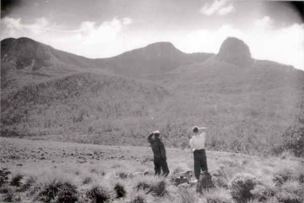
| Keith Lancaster and Chris Binks viewing High Dome | |
After dinner, with only cameras and a few eats, etc. to carry, we set off at 12.45 p.m., wondering what hazards the forested slopes ahead had in store for us and whether time would permit us to climb all three peaks and regain our camp ere nightfall. But our luck held good. The forest remained surprisingly free from scrub. The broad aisles running through the pandannis were a bush-walker’s dream. In a very short while we reached the crest of the ridge running southwards from the western peak of' High Dome and we were able to peer down into a fine little lake in the hollow between us and the rocky south eastern peak. Our only discomfiture lay in the short patch of scopari which presaged our arrival at the scree base, from which an easy, though steep, climb ensued to the top. It was not until this stage that the party, which had paced so evenly and solidly together throughout the long journey out, showed any signs of splitting up. Thus the various elements continued on in accordance with their individual energy or temperament.
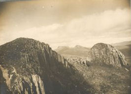
Reaching the top of the western peak (4250’ – 8½m. – 1.35 p.m.), a small cairn was constructed and an inspection of the full panorama made, whilst the more impetuous section (the “wild peak baggers” see Page 12 of "Skyline" No.2) were careering on to the highest peak. The view was just as magnificent as expected. High mountains and wild country appeared in all directions. Gone were our worries about time for only a few minutes' gambol separated us from the highest peak to the east, whilst the jagged tooth to its south looked a reasonable proposition. This rocky spire and the lake in the forest below formed an interesting foreground with forests, plains and hills running away in all directions towards more imposing peaks like the Eldons, the Frenchman and the peaks of the National Park.
At 1.45 p.m. we were all under way for the highest peak, descending slightly
to the col and then up a clear, easy slope to the top (4300’ - 9m.
- 2 p.m.). The view from this cold summit was even better than from the
other peak. The new highlight available was the Amphitheatre with its
tiers of unusual shelves spaced one below another and running the full
distance around its huge perimeter, with a small lake occupying the base
of “the pit". A magnetic check of the various points of interest
visible was commenced:
western peak of High Dome, 263; Eldons were obscured behind this peak;
Mt. Lyell, 244;
Owcn, 233;
Jukes, 223;
Frenchman's Cap, 185;
Pyramid Hill, 164;
Gell, 149;
Gould's Sugar Loaf, 138;
Rufus, 137;
Hugel, 136;
Cuvier, 116;
Olympus –
At this stage we abandoned the check as the strong wind made it impossible
to hold the compass steady enough for accuracy. Thus the northern semi
circle passed unchecked, even though we record that the following peaks
were visible in this order: Olympus, Byron, Manfred, Horizontal Hill,
Gould, Guardians, Parthenon, Acropolis, Geryon, Walled Mt., Ossa, Mac's
Mt., Eros; then clouds galore blotted out everything farther northwards
clouds which were steadily increasing and lowering.
Another cairn was erected on this peak and, after much photography, we descended southwards towards the rocky spire which formed the western boundary of the Amphitheatre. At its base, we found Chris. already half way up, so Bess and I followed on up the steep rock to the top of High Dome's third and most spectacular peak (4120’ – 9¾m. - 3.15 p.m.). From here the Amphitheatre was revealed to best advantage, whilst other sections of High Dome and the route homeward were more intimately exposed. The gathering clouds from the north west now were skimming the two higher peaks and a change in the weather looked probable in the near future.
We left the final peak after a brief stay and descended to the little lake at its western base. Then (10½m. - 4 p.m.) we skirted its western shore to regain the low ridge beyond via clear ‘roo pads and thence down through the open forest back to our camp site (2900’ – 11m. - 4.35 p.m.). Thus the three peaks had been accounted for in unpredictably easy fashion and we had plenty of time now on our hands. With the anxiety of what ordeals may lie ahead dissipated, even the more cautious male members, whose reluctance to sacrifice any energy in camp fatigue had been so evident, at last were galvanised into activity. After our Walks Secretary had contributed a diligent half-hour to the collection of firewood with most meagre results, he was able to entice expert assistance to his cause in the representative from the Forestry Commission. We were treated then to a fascinating display of just how dead trees should be demolished. The scientific method applied necessitated one member climbing the trunk and swinging lustily from above whilst the other heaved prodigiously at the trunk. The tree shook and groaned under the combined pressure; then came a loud, creaking sound, followed by a blood curdling expression in Gaelic, a dull thud and an agonising groan and we espied the Forestry Commission representative reclining somewhat uncomfortably upon the green sward, clasping the one foot of dead branch he had secured in one hand and a vulnerable spot in his anatomy with the other. Operations were terminated whilst first aid was administered and, whilst copious repairs were being made to torn garments to obscure a “stern outlook", it says much for the determination of the Celts that the convalescing expert returned and, discarding the scientific for the more prosaic method, proceeded to attack the unfortunate tree trunk with the axe. The remainder of the day passed by in blissful tranquillity.
We broke camp on Sunday at 8.55 a.m. under cloudy skies with a strong N.W. wind and a light sprinkle which soon ceased. We followed the track homeward, our outward experience facilitating its finding. We reached the edge of the high ridge (3000’ – 3m. – 10.10 a.m.) and paused for a last look of High Dome ere the clouds fulfilled their threat to swallow it. Our journey along 'the ridge top was very leisurely. We reached the other end under Pyramid Hill (3200’ - 6m. - 11.55 a.m.) and left the track to climb that peak. We wasted considerable time trying to find water in a wrong gully due to a faulty memory and, at length, chose to have dinner at the tadpole pool in the open gully just under the peak (3430’ – 6½m. - 12.55 p.m.).
At 2.20 p.m. we left for the summit of Pyramid Hill and a short easy walk up an ideal surface soon brought us to the top, (3900’ - 7m. - 2.30 p.m.). A cold wind and gathering clouds gave us a cool reception. Still we lingered a while, examining the diminishing view and quite a good one it was, as many of the surrounding peaks still showed out prominently whilst the nearby gorges, forests, plains, cirques and ridges added much to our enjoyment. Upon leaving the summit at 3 p.m., our progress was halted for nearly an hour searching the fossil bearing outcrop below for first rate specimens of fossilised marine life.
Back at the pool, we re packed and left at 4 p.m., regaining the track through the scrub below (3200’ – 7¾m. - 4.15 p.m.) and then down the ridge side and back to our first night camp in the small clearing (2950’ – 8¾m. - 4.50 p.m.). The threatening clouds receded towards nightfall and a cold night followed.
Monday morning broke cold and cloudy and we were away at 7.45 a.m. hoping to account for Gould's Sugar Loaf on our return homewards zero time for arrival at the bus being 5 p.m.. We found the track much easier to follow now and made much better time, especially on the section to the Canning tributary crossing (2850’ – 2½m. - 8.35-42 a.m.). The long climb up to the clear ridge was undertaken under humid conditions. Sweat came dripping from every pore and pouring from every “drip”. At last the ridge top was gained (3550’ – 3¼m. - 9.5 a.m) and we pressed across the “plateau” towards Gould's Sugar Loaf. The N.W. wind gained in intensity as we followed the stakes along and we were almost blown up the final rise to the peak (4400’ - 5m. – 9.55 a.m.). Under such windy and cold conditions we reduced our stay to a minimum, especially as the view was very curtailed.
Leaving at 10.15 a.m., we encountered the storm almost immediately and
it was rather an unpleasant trip back down to the Cuvier outflow from
Lake Petrarch where we halted for dinner (2750’ – 10½m.
– 12.50-1.53 p.m.) and then sped onwards to regain our bus at Cynthia
Bay (2420’ – 17½m. – 3.50 p.m.). Leaving in the
bus at 5 p.m., we had a good trip homewards, arriving at Launceston shortly
before midnight.