by
Keith Lancaster
Note:
This report has been scanned in as written. I have included the height,
distance and time indications where used, e.g.:
(1000'- 12m.- 4.45p.m.)
which read as follows: height in feet - miles for the day - time.
Mt. Rogoona attracted attention early in 1957 and I would have appreciated a long week-end in which to tackle the trip. However, it was not possible to arrange this, so we had to try a two-day blitzkrieg instead.
Leaving home at 6.0 a.m. on Friday, March 22nd. 1957 with John Olding, John Wanless and Bob Rusher, I reached Bronte Park at 9.30 p.m., stopping the night with John Daniel (2400’). We were astir early in the morning and away from Johnny's well before 6 a.m., but we were held up whilst Johnny dragged the sixth member, Eddie King, out of bed and hastily prepared him for the fray. At 6.7 a.m. we left Bronte Park, took the turn on the left at the bottom of the hill, climbing around the Pine Tier Dam and halting at the abandoned homestead of Gowan Brae (2700’).
Starting the foot journey at 7.35 a.m., we immediately crossed the Nive River over a light wooden bridge, crossed the clear paddock to the north-east, picking up the old waggon trail on the rise beyond the first fence. Following this rough “road” northwards, we passed through the first slip-rails (1¼m. - 8 a.m.) after following up a fence for quite a distance. The trail continued in a N.N.E. direction to a further set of slip-rails (2¾m. - 8.30 a.m.). From here the “road” vanishes, but the faint marks of a jeep trail carry on, exploiting the line of clearings, and we made a course in close proximity, coming out on the right bank of the Little River (4½m. - 9.5 a.m.).
The stream was followed closely for a while, after which we turned away to the left and passed through a gateway on the open plain (5m. - 9.15 a.m.). As the plain terminates, we moved in closer to the river on rockier ground, finding the way still quite open and frequently using the route taken by the jeep. The southern end of the aptly-named Reedy Lake was reached (7m. – 9.55 a.m.) and the shore followed northwards around its western side until we left it behind and debouched on the southern shore of Lake Olive (3288’ – 8½m. – 10.20 a.m.), a much larger lake.
Here we had our first spell, resuming at 10.38 a.m. to cross the Little River near the lake’s outflow and ascend the steep hill beyond through scrub-free eucalypts. From the top we sighted Lake Naomi on the other side but, after a short descent, continued northwards along the clearer leads and later north-west to close in on Pats Tarn. After skirting the eastern shore, we re-crossed the Little River just north of Pats Tarn near its inflow from Lake Pogana (12m. - 11.55 a.m.).
In skirting the western shore of Lake Pogana, we encountered our first scrub, low and wet - the latter from overnight drizzle and morning mist. We met some delay in crossing three streams close together - the inflow from Lake Mikany and the two forks of the Little River coming from Three Arm Lake. Lunch was taken after the third crossing (3440’ – 12¾m. - 12.12 p.m.).
A review of our stocks gave us fair prospects of gaining Rogoona by nightfall. We appeared to be more than half way according to the map, although the unknown section lie ahead. The sun broke through the canopy of clouds during lunch and a rapid clearing increased our hopes.
At 1.12 p.m. we set off northwards through what clear leads offered. As we regained the Little River, we encountered some trouble with the surrounding fagus before breaking clear. We passed a small lagoon (14¼m. - 1.40 p.m.), then crossed the river to its western bank and soon reached the southern End of Three Arm Lake. After a pause for photography (3650’ – 15½m. – 2.5-10 p.m.), we continued westward until we could swing north and cross the stream between the main lake and its western sector (3645’ - 16m. 2.15 p.m.). Resuming westward, we paralleled the lakeshore, passing by its western extremity (17m. - 2.35 p.m.). We gained a little altitude as we continued westward, the Acropolis showing clearly ahead, but the view of Rogoona was not imposing. Nearing the top of the saddle ahead, we swung a little to the right, still enjoying fairly open going until some scrub was encountered as we descended towards the upper valley of the Mersey. It was pleasant to emerge from the scrub at this attractive, sheltered valley and dump our packs at a chosen campsite (3350’ – 20½m. - 4 p.m.).
We were about half a mile north of Lake Meston and the foothills of Rogoona lie directly ahead. The wisest course appeared to be to leave our gear here, press on with torches in reserve and try to effect the ascent in late afternoon, thus giving us the full day on the morrow to walk out and return home.
Surprisingly, Eddie decided to stay at the camp - he was one of the better walkers but had little interest in the mountain itself. The remainder resumed at 4.20 p.m. Choosing the direct route in favour of a more circuitous early choice as vegetation seemed thick in the gullies, we were halted by dense fagus in trying to shoulder the first rise and were obliged to make a ridge-top crossing. From the top we were obliged to descend sharply into a valley before ascending the next ridge. Again we had to make a ridge-top crossing and again descended into another small valley with its clear trough.
On the crest of the third ridge, Johnny decided to give the mountain away and return to camp before dark. He was obviously very tired, but he was not the only one. The remainder hastened westward, again descending into another valley and passing the southern edge of an alpine tarn in its trough (3650’ – 22¼m. - 5.20 p.m.). The next rise was much broader and we were close under the main mountain massif before it plunged away once more into the inevitable valley. The ensuing climb was steep and long, but now free from scrub. The toll of prolonged scrub-bashing and the increased pace was telling, and the party strung out. I was lagging behind badly at this stage and I was a bad last to reach the crest. We were dismayed to find there was still a further height yet to scale, although very little higher.
There was some query about the wisdom of continuing as it was dusk now,
but how could one acknowledge defeat so easily after coming so far and
enduring so much? Cramp and exhaustion was clearly in evidence but we
battled down the short slope into the last valley, passed its tiny alpine
tarn (24¼m. - 6.15 p.m.), and clambered up the ensuing rocks, arriving
at the top of Rogoona in strung out Indian file (4450’ - 25m. -
6.29-33 p.m.).
 |
|
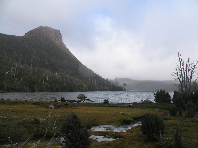
| Mt. Rogoona from Lake Myrtle | ©
John Evans, 2005 |
It was quite dark. I felt too tired to bother with the surroundings. Red clouds along the western horizon still reflected some solar glow. Silhouetted boldly in this ruddy glow were the giant peaks of the Reserve – Gould, Acropolis, Geryon, Falling, Cathedral, Ossa, and several others. Lake Myrtle lay below us, away down beneath hundreds of feet of cliffs. The waters of Lakes Louisa and Adelaide, much farther away to the north-east, still shone out from the sombre darkness of surrounding forests, whilst away beyond, Clumner Bluff, the Walls of Jerusalem, and other heights were dimly recognisable.
The scene was shrouded by the gathering gloom, but it was enough to convince us that this was a vantage point equal to the best. How inviting the waters of the large alpine lakes would appear on a warm summer’s day. What a scene the countless lesser lakes would present, to say nothing of the grandeur of those high crags in the Du Cane Range area. What a pity we had not waited until a three-day trip was possible.
However, our stay on top occupied little more than five minutes. We were anxious to find our way back to the adjoining height before complete darkness made the rock-hopping too precarious. We planned to swing a little south of our outward course and try to avoid crossing all the ridge-crests. We made good progress early, discovering fairly open leads, but at length thicker scrub induced us to turn more and more to the right. Eventually the fagus became too difficult, so we descended to the shore of Lake Meston, hoping for a passage around the water's edge (8.7 p.m.).
For a few yards the policy succeeded, until the encroaching fagus made us wade around it in a foot of water, then two feet, then more. Again we tried conclusions with the scrub above the water’s edge. Difficult enough in daylight, it was a nightmare under these circumstances. At intervals we would inspect the lakeshore, fruitlessly. Ultimately, near the north-eastern corner, we found half a mile of shallow water which brought us to a tiny shingle beach near the inflow of the Mersey.
For some time we had seen a great fiery glow ahead, Johnny's valiant guiding beacon. From the beach it seemed that half the hillside must be ablaze, yet next morning we could barely find the spots where the fires had been. Our exhausted bodies gave us a feeling of having battled away most of the night, but we were surprised at what our watches showed when we reached the camp (3350’ -30m. - 9.30 p.m.). How we appreciated that hot meal and that hot drink, before tumbling into our sleeping bags to snatch a few hours’ rest in preparation for the morrow.
It was a listless party which arose next morning and finally broke camp at 8.20 a.m. Going a quarter of a mile down-stream, we found a relatively good course to the left, up the trough of the long broad valley, leading eastward. We reached the first lake in the trough (1½m. - 9 a.m.) and skirted a few more before breasting the low crest of the pass, regaining our outward course and having a spell at the western extremity of Three Arm Lake (3660’ – 3½m. - 10.0-15 a.m.). Again crossing the lake at the narrows (3650’ – 4½m. - 10.33 a.m.), we did not farewell it until 10.54 a.m. (3650’ – 5½m.). Reaching the northern end of Lake Pogana (3440’ – 7¾m. - 11.30 a.m.) we succeeded in skirting it and crossing its outflow before lunching at the northern end of Pats Tarn (3435’ – 8¾m. - noon-1.8 p.m.).
Retracing our course, we had a spell at the little beach at the southern end of Lake Olive (3288’ - 12m. - 2.25-40 p.m.). Our next rest was at the gateway on the plain near the Little River (15½m. 3.40-57 p.m.). The first slip-rails were reached (17¾m. - 4.50 p.m.) and then the second slip-rails (19¼m. - 5.19 p.m.) and finally Gowan Brae was gained (2700’ – 20½m. - 5.45 p.m.).
The two car loads set off after a change of clothes was effected and a few eats at 6.10 p.m., each going its own way from Bronte Park. We reached Deloraine at 8.45 p.m. and Launceston at 9.40 p.m..