by
Keith Lancaster
Note: The reports have been scanned in as written. I have included the height and distance indications, e.g.:
(1000'- 12m.- 4.45p.m.)
which read as follows: height in feet - miles for the day - time.
Tarn on Schnells Ridge in snow
Driving farther southwards, I inspected the land to the east, seeking the best approach to Schnells Ridge but low clouds didn't lend any assistance. After some exploration, I parked my car south of the 17-mile peg on the south side of Red Tape Creek. From here the lowest shoulder on the long ridge to the east lay only a short distance N.E. and there was a short bull-dozed gravel track leading a few yards that way.
We had an early lunch and left the car (1030') at 11.50 p.m.. Light showers and a S.W. wind accompanied our ascent of the ridge which was steep but relatively clear. Reaching the ridge-crest (1930' - 1½m. - 1.10-28 p.m.), we turned south for a short distance to gain a ridge running down towards the Anne River. After a slow and tedious descent, we reached the Anne River around 2.30 p.m. and scouted around for a crossing. The river is only about 15' wide but was running swiftly with about 3' depth of water through a channel so evenly carved that it had the appearance of being artificially created. We found no log crossing and soon realised that it was most improbable as there was not a tree of any proportion around and all obvious regrowth less than thirty years old. Obviously this must have been one of the areas affected by the Pedder fires of the 40's and that the fires must have completely devoured everything around as no old dead timber could be seen.
At length the icy stream had to be waded and we proceeded to set up camp on the eastern bank as it was pointless in the present weather to push up the ridge beyond leading up to the miscellany of tops that covered quite a broad area of the sprawling massif called Schnells Ridge. A vain search was made for an open site, whereupon I hacked out a site amongst the trees on the bank as the button grass was too boggy. Showers hindered operations but we had ample time to spare for camp duties. We had a fairly comfortable night, although it was very cold and showery.
On Sunday, Nov. 1st. I was out before 7 a.m. at the first break in the showers. There was much blue sky showing as I lit the fire, but showers began again during breakfast and persisted for some time. The ground was very sodden and the river had risen an inch. Firewood was very difficult to find.
We were away, travelling light, at 9.30 a.m. during a break in the showers, heading N.W. for the base of a climbing ridge which led roughly N.E.. Showers returned as we climbed and the weather was extremely cold. A break in the clouds revealed Mts. Eliza, Sarah Jane and Lot, their summits wreathed in clouds and their slopes coated luxuriantly with snow.
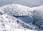
On top of the ridge we rested (2230' - ¾m. - 10.14-41 a.m.) and recorded directions of visible points as a precaution against thick mist. We turned eastward and climbed towards a higher ridge, encountering a snow storm as we neared its crest. We took shelter in the lee of a rock just below the summit on its eastern side (2930' - 1¼m. - 11.0-5 a.m.). A tiny col joined up with a high ridge E. by S. and we pushed on to its summit (3680' - 2½m. - noon). This would be one of the higher summits of Schnells Ridge but unlikely the highest. A peak to the east, beyond a broad gully which contained a sizeable tarn, appeared to be the highest. Another two peaks, to S.E. and S. respectively, also appeared a little higher than ours, but time and the condition of my companion made it unwise to press on farther, so the retreat began at 12.17 p.m..
Our descent (a retracing of our ascent course) was into the wind with cold sago snow in our faces. At first with cloud mist present, our footprints in the 2" to 3" snow on the summit ridge guided us safely and thereafter the mist was above us. A few photos were taken between showers, especially of the two glacial tarns cupped in our original ascent ridge. These tarns, visible from most peaks of the Anne group, had intrigued me in years gone past. (photo)
Back at camp (1460' - 5m. - 1.30 p.m.), the showers began afresh and, noting the river was still rising, we thought it wise to push out to the road and car, where better comforts should be available. We packed up and broke camp at 2.25 p.m. but immediately had to run the gauntlet of the racing river. The water was over waist deep and a footing was hard to hold on the slippery and uneven bed. At last we were safely across although half frozen in the process. A drying off and the addition of some upper garments that were carried across restored just a little warmth and we set off westward again at 2.40 p.m..
We returned by a different route, walking upstream for 100 yds. and then N.W. across to a ridge. About three-quarters of the way up, we commenced sidling the ridge on its southern side to make position towards the ridge crest overlooking the road which was next reached (6½m. - 3.40 p.m.). In descending to the road there was a minor set-back as we had to change from the ridge branch we started upon to another 100 yds. south before getting on course to drop down to the gravelled track and so on to regain the car (1030' - 8m. - 5.5 p.m.).
The weather was still unsettled but the fine intervals were now longer than the showers. After completing a dry change and thus engendering a much more comfortable state, we drove off southwards at 5.27 p.m. as far as the H.E.C. barrier across the road looking for a hut or good campsite. We returned and selected a site off the road near the 18-mile peg. Firewood and water were available but weather breaks permitted only the cooking of a meal and no drying of clothes. As we retired at 9 p.m. there was still a steady persistent drizzle.
It was still showery next morning but we managed to dry out a few clothes before leaving at 10 a.m.. At Condominium Creek we met the L.W.C. party and went with them to inspect the old Huon Crossing. As we drove out, the weather seemed to im-prove. At Sandfly Creek I collected a Cambrian rock (banded argillate). Lunch was taken at the picnic round near the junction of the Strathgordon and Scots Peak Dam roads. The remaining journey home was without incident.

Tarn on Schnells Ridge in the snow 1/11/1970
If
you would like more information on Keith Lancaster's diaries, please feel
free to send me an email.